SR15 Development – Community Survey Results
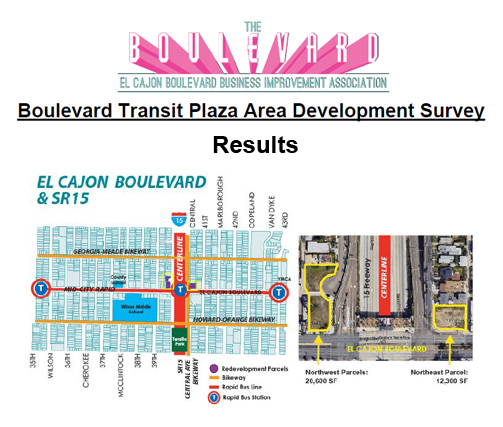
Background: Construction of the Mid-City segment of State Route 15 was a watershed event for the community, which had long suffered the impacts of cars passing through its neighborhoods. Recognizing the extraordinary circumstances surrounding this project, the design of the freeway was intensely negotiated, with the goal of making the new freeway both a regional asset and a catalyst for neighborhood reinvestment. Many design amenities resulted from this process, including construction of the freeway in a below-grade channel to minimize the division of the community; creation of a four acre park over one block of the freeway; enhanced pedestrian linkages across the freeway; and integration of the CenterLine Bus Rapid Transit into the median of the freeway, supported by expanded overcrossings to serve as transit plazas at the interchanges of SR-15 at University Avenue and El Cajon Boulevard. For over 20 years the parcels on the northwest and northeast corners of El Cajon Boulevard and the 15 Freeway have sat vacant with the idea of creating a transit oriented development that supports transit and the community’s needs.
The sites are currently owned by public entities. The northwest parcels are under control of Civic San Diego and the City of San Diego owns the northeast parcel. The Economic Development Committee of The El Cajon Boulevard Business Improvement association has been working with the two entities with a goal of having a simultaneous release of request for proposals (RFPs) to develop the properties. The intent is to capitalize on any synergies which can be created through a joint or complementary development of the parcels.
Survey Development: In preparation for the long-term development of the parcels, community input on desired uses was sought to inform the RFP process. A survey was developed through The Boulevard’s Economic Development Committee. The committee is made up of community stakeholders including; residents, partner non-profit organizations, community planning group members, local business owners, Civic San Diego, and The City of San Diego.
The northwest parcels are in the Normal Heights Community Planning area and within Council District Three. The northeast parcel falls within the Kensington-Talmadge Planning area and is in Council District Nine. Representatives from both planning areas attended meetings and contributed to the development of the survey. Representatives from both Council offices were also consulted.
The survey focus was on potential uses for the sites (Commercial, Office, Housing, Multi-Modal Connections, Civic/Community, Other). A stakeholder category question was also included (Local Resident, Property Owner, Community Group Member, El Cajon Boulevard Business Owner, Other). There were 10 questions in total, with an estimated five minute completion time.
Survey Distribution: The survey was available to complete online. Paper copies were also printed and given to residents near the lots and were available through Bikes Del Pueblo, which is located on the northeast parcel. An option to deliver a paper survey and translation services were also made available for anyone who requested it. Paper copies were also given to a resident on Central Ave. who was making them available to her neighbors. The goal was to focus the outreach around the development area as much as possible. Representatives from the two planning groups the parcels are located in (Normal Heights and Kensington-Talmadge) were emailed the survey flyer and link to their distribution groups and announcements were made at the planning group meetings. The survey link was also shared with the City Heights Area Planning Committee, which is located adjacent to the sites. A link was also posted on Next Door and The Boulevard BIA website (theboulevard.org).

Survey Response: 108 responses were collected. All have been completed online. A large majority (91%) of the responses have been from local residents and property owners. Civic/Community was the highest ranking use overall, Commercial came in second and Housing was third. A rendering showing a mixed-use development with housing above community or commercial uses was seen as a good or really good fit by a majority (55%) of the respondents. An open air event space with commercial tenants was also seen as a positive use, with (59%) declaring it a good fit.


The survey and results can be found here.